What is a Neighborhood Group?
The most important element of your involvement with FSO is to become an active member of your own neighborhood. We have 16 different Neighborhood Groups, each with at least one leader who is our key contact. The leader organizes neighborhood meetings, workdays, and more depending on the desires of the group.
A Neighborhood Group…
- Shares contact information so that in the case of an emergency you can reach one another and help one another
- Identifies crucial neighborhood resources, making it easy to locate in an emergency (secondary emergency exits through a neighbor’s property, extra water sources or back up generators)
- Connects individuals to a greater collective so we can share our strengths and gifts
- Organizes community work days in conjunction with FSO strategies to reduce risk
How can I get involved?
- Locate your group on the map below
- Study and download the directory below for your reference
- Reach out to info@saferwestcounty.org to get connected to your Neighborhood Group Leader
Occidental Neighborhood Group Directory
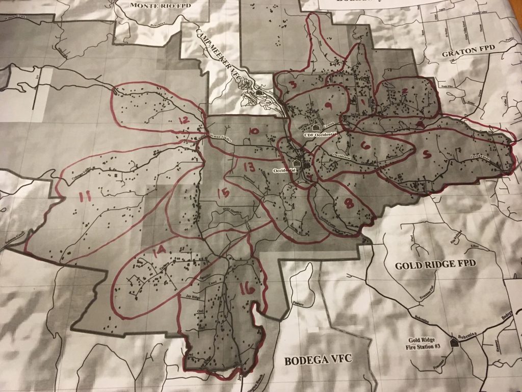
| #1 Harrison Grade Road Area (HGR) Harrison Grade Road (from Cal Fire intersection to Green Valley Road) Harrison Grade Place Tanuda Road Heather Lane Harmony Lane Dupont Road (HGR to Harmony Lane) Morelli Lane (HGR to Heather Lane) Stoetz Lane (to and including 4551) Graton Road (only #5502) | #2 Dupont Area Dupont Road (from Harmony to the end) Bones Lane | #3 Stoetz and Morelli Area Stoetz Lane Morelli Lane Rabbit Hill Road | #4 Graton Road & Green Hill Area Graton Road (from Tanuda Road to Green Hill Road) Green Hill Road (on the boundary between Occidental and Graton Fire Departments) |
| #5 East Occidental Road Area Occidental Road (from Frati to end of Occidental Fire Department area near Furlong Road) Jonive Road (top end to end of Occidental Fire Department area) Crystal Lane Vinegar Ridge | #6 West Occidental Road Area Occidental Road (From Frati Lane to town) Frati Lane Facendini Lane Sota Way Lu-Dan Road | #7 Downtown Occidental Bohemian Hwy (from Union Hotel Grove to Scout’s Camp) Jomark Lane Main Street 1st, 2nd, 3rd Streets Hill Street Minna Street Church Street Bush Street Doris Murphy Court Kit Lane Harmony Village Circle | #8 South Bohemian Highway Bohemian Hwy (Scout’s Camp to Freestone) Scout’s Camp Road (Marika Drive, Gerson Drive, Freestone Flat Road: in Gold Ridge Fire Dept) (Scott Robin Road, Freestone Street, El Camino Bodega: in Gold Ridge Fire Dept) |
| #9 Acreage & Highland Area Bohemian Hwy (from downtown Occidental to Camp Meeker Fire Department area) Acreage Lane Palin Lane Hillcrest Avenue Lapham Lane Highland Road Stepps Road Occidental-Camp Meeker Road | #10 East Coleman Valley Road Area Coleman Valley Road (from town to Joy Road) Timber Lane | #11 West Coleman Valley Road & Fitzpatrick Lane Area Coleman Valley Road (from Joy Road west) Fitzpatrick Lane Docs Ranch Road | #12 Willow Creek Road (From Coleman Valley Road to Willow Creek Open Space gate) |
| #13 Lower Bittner Road Area Bittner Road (from Deer Meadow down to town) Marra Road Freeman Ranch Road Wyammy Ranch Road Westwood Lane | #14 Taylor Lane | #15 Upper Joy Road & Deer Meadow Lane Area Joy Road (Coleman Valley to 3000 Joy Rd) Deer Meadow Lane | #16 Lower Joy Road Area Joy Road (from 3000 south) Jennifer Drive Lauri Lane Joy Ridge Road Owl Road Burl Lane Joy Woods Way |